Swissair SR111 Crash: Supplimentary Web Site.
(Last update: 2020-September-21, 21:35)
This site is dedicated to the memory of the 229 people who lost their lives on September 3, 1998, in the crash of Swissair flight 111.
This site was off-line from May 23 of 2005 until February 1st, 2006, due to a server configuration error. \ My deepest apologies to all who use it regularly for reference purposes. \ This was an entirely unintentional error, and the server is now back on-line and has been checked for consistency and updated as much as possible. \ There are a very few images that are still missing and no longer available (I searched everywhere for them, without success), \ and many of the "useful links" have now expired, but judging by the number of hits that this site still gets, \ many people find it very useful still today, even 22 years later.
Click here to go directly to the discussion forum.
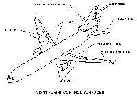
Technical Information:
Various kinds of maps, old and new:


 Detail of Aspotogan Peninsula (Blandford)
References & Indexes:
Rob Plenert's Transcript of Boeing's intervention in SBA court hearings
Unrelated Reports and Comments
Statistics and Guestbook:
Total hits on this site
since September 15, 1998
(Hit counter courtesy of LinkExchange)
(Click here for more statistics about this web site)
.
 *****
*****

Click here to go to the on-line discussion forum
DISCLAIMER:
This is NOT an official web site. It is neither produced nor endorsed by any aviation authority, airline, aircraft manufacturer, or by any other company. The entire contents of this web site represents pure speculation and opinions of several individuals. Information contained on this site has been compiled and provided voluntarily by many individuals. No information contained on this site may be used in any litigation, or for any legal or commercial purposes whatsoever. Information contained herein is for the exclusive use of those participating in the on-going discussion regarding the crash of Swissair flight SR 111. Accuracy of the information contained herein is neither claimed nor implied. Use of the material contained on this site is at the entire risk of the user. Some of the material contained here is copyright of the original authors. Details are available on request. The author, contributors and operators of this site have no liability nor responsibility whatsoever, to any person, organization, or entity with respect to any loss or damage caused, or allegedly caused, directly or indirectly, in whatever way, manner or means, by the information contained in this site.
WARNING! The maps, diagrams, approach plates and other information on this web site SHOULD NOT be used for maintenance, flight planning or navigation purposes. This information is supplied and intended for general reference purposes ONLY. Accuracy is neither implied nor assumed. Use of the information supplied here is at your own risk and responsibility.
IN OTHER WORDS, WHATEVER YOU DO WITH THE STUFF YOU FIND HERE IS YOUR RESPONSIBILITY AND YOUR PROBLEM, NOT MINE OR ANYONE ELSES!
(Sorry to have to mess up the site by including the above, but my lawyers think it would be a good idea.)
Comments/Suggestions:
Webmaster